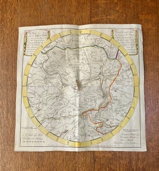
A MAP OF 5 MILES ROUND THE CITY OF BATH. On a scale of one inch & half to a mile, from an actual survey, including all the new roads, with alterations & improvements to the present time 1799. Printed for and sold by A. Taylor & W. Meyler. Booksellers of whom may be had a New Plan of the City of Bath with the additional buildings. Bath, published according to Act of Parliament, 25th March 1799. Price 1 shilling 6 pence. W. Hibbert, Bath Sculpt.
Printed for and sold by A. Taylor & W. Meyler. Bath. 1799, 1799. A fine and bright example of this rare map. (17.3 x 17.2 inches). Hand coloured. Paper watermarked 1797. Loosely folded into four but with no damage to the creases or edges. A remarkable survivor in such nice..... More